Urban rivers: pleasure or danger; making space for water
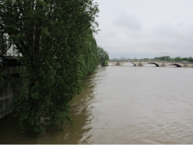
Urban rivers are an integral part of cities. During the urbanisation process, the sinuous and unpredictable flow of the river has been controlled, dammed and straightened. The traditional, engineered flood defence in most cases keeps the water at bay, but with climate change the intensity and frequency of flood events increases. It is timely to question the idea of controlling water flow by confining rivers between walls, or forcing them through culverts and to consider more imaginative solutions, making space for water in urban environment. My part-time PhD-research looks at urban forms in riverside locations in old industrial cities. During my latest trip to Paris, at the end of May, I had a good demonstration of the extent of the problem caused by flood risk. The city where I grew up was transformed. Following an unprecedented continuous period of persistent rain, the river Seine became dangerous through a powerful flow of water that was both uncontrollable and polluted. The Seine rose by nearly 6 metres. The traffic on the water was stopped. The rise of the water was fast and left some of the people living on barges stranded with their boats threatened by the force of the current. Four museums closed and emergency plans were put in operation to move important artefacts to the higher floors in the Louvres and Musee d’Orsay.
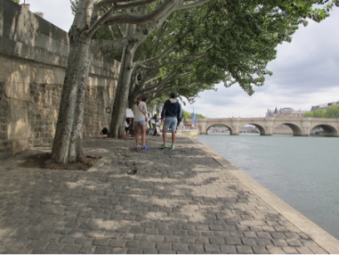
Historically Paris developed along the river Seine with the first settlement located on the islands in its centre. The river at the time provided protection and was essential for transport and trade activities. The fact that the street numbering system radiates out from the river illustrates its importance in the development of the city. Since the 19th century the riverside in Paris consists mainly of hard surfaces, planted with trees. The lower quays provide access to boats and in some places fast routes through the city. However for the Parisians it is also an escape from the busy noisy environment. The narrow secluded linear spaces between the water and the retaining walls offer privacy and are often used in summer for sun bathing.
In the past few years the municipality has multiplied initiatives to reclaim the linear spaces along the water for people and leisure activities. The annual Paris Plage event sees the urban highway closed off from cars and filled with sand, deckchairs, palm trees and playful activities. This temporary event has been so successful that the plan is to remove car traffic altogether from the lower quays and reclaim these spaces permanently for walking, cycling and other sports and leisure activities. Between the Pont de l’Alma and Quai d’Orsay, a new type of temporary linear open space has been developed using containers and floating gardens. The interventions are minimalist and temporary. The retaining walls are transformed in climbing structures. Containers, positioned along the water edge, are adapted to house cafes and champagne bars, while others can be rented for short periods to accommodate parties or to provide pop up offices. The boats docked in the water provide space for gardens and house restaurants. When the flood came these installations proved to be resilient. The containers and other furniture were safely lifted to higher grounds. The resilience of open spaces to the flood was also illustrated in the East of Paris at the Quai Saint Bernard. The open-air sculpture park proved a great attraction in its flooded state with the objects being seen in a different light, as they were partly submerged.
This time the Seine remained within its hard engineered corridor, but this may not always be the case. The more porous quay Saint Bernard park and the large mature trees enabled some of the water to be absorbed but much more porous surface area and trees would be needed to mitigate more extreme flood events. For this reason it is essential to explore new ideas. Rivers cannot be dissociated from the surrounding urban form and more research is needed in the field of urbanism to inform the decision making process, especially in relation to brownfield site regeneration in riverside locations. The goal of the PhD research is to deliver a framework of urban form options and design guidance to illustrate more resilient approaches to urban flooding.

